
 mail@mksurveys.co.uk
 01908 565561
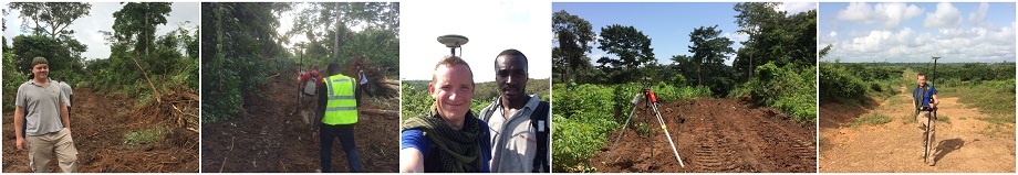
Nov 2014: Ghana Surveys
MA Team from MK Surveys have just spent the last 4 weeks surveying three sites in Ghana for proposed hospitals. Two of the sites were “green field sites” (although Jungle is a better description) and the third was an existing hospital which is to undergo re-development. Our team had to endure harsh conditions; 35 degrees Celsius, 90% humidity, Spitting Cobras and treacherous ground conditions. A big thank you to Simon, Liam and Kofi who worked very hard and did a great job
Nov 2014: Oxford Office Relocation
Due to continued expansion we are pleased to announce that our MK Surveys Oxford Office has relocated to larger premises. From the 12th November our new address will be: Unit 10 Cholswell Court Shippon Abingdon Oxfordshire OX13 6HX Tel. 01865 594979
October 2014: Happy 35th Birthday TSA
HAPPY 35TH BIRTHDAY TO THE SURVEY ASSOCIATION The 3rd October 2014 marks 35 years since TSA was incorporated in 1979. The Survey Association, known generally as TSA, is the trade body for commercial survey companies in the UK. The association was formed in 1979 to give a focus for private sector businesses in land and hydrographic survey. It is important to realise, however, that it is not a regulatory body. The role of TSA is to promote best practice amongst its members, provide a forum for members for discussion, debate and continuing professional development and, to the wider audience such as engineers and architects, provide guidance on new methods and techniques and a list of suitably qualified and experienced companies.
July 2014: MK Surveys Utility Department Welcome New British Standard
MK Surveys Utility Department welcome the new Specification for Underground Utility Detection, Verification and Location or to give it the official BSI reference PAS 128:2014 (Publicly Available Specification) that was officially launched at the headquarters of the Institute of Civil Engineers (ICE) on 30th June 2014. The need for a British Standard was conceived back in 2012 as a direct result of rapid growth within an unregulated Utility Survey Industry, aligned with concerns shared by many (ourselves included) about the lack of understanding when requesting utility surveys, the range & variation in detection methods employed (often unappreciated by the end user) and the many different forms of utility data presentation. Hence MK Surveys closely monitored and supported development of the PAS 128:2014 standard via our memberships of TSA, UMA and EuroGPR and indeed our views were sought, considered and influenced some minor changes within the document as part of the draft review process completed towards the end of 2013.
July 2014: MIRA Technolgy Park, Nuneaton
Further to surveying 7000 metres of the main A5 (T) Watling Street for highway re-design and development enabling. MK Surveys have returned to The MIRA Technology Park Enterprise Zone, near to Nuneaton for the next phase of survey works that will include the new dual carriageway access onto the site (as shown to the left), plus areas that will form the initial phases of the construction and also general updates to existing survey data. The Enterprise Zone will see the phased development of the existing Advanced Engineering, Research and Testing Facility at MIRA. The vision is for the Enterprise Zone to become the most advanced, independent transport technology development in Europe, generating more than 2,000 jobs over the next 10 years. It will focus on a range of transport sectors including automotive, aerospace, rail and defence.
June 2014: Up for the Challenge - M4 Junction 16
MK Surveys have just completed a particularly challenging topographical survey of the M4 Junction 16 southwest of Swindon. Probably one of the most difficult sites to survey due to the volume of traffic and limited safe areas, a variety of survey methodologies had to be employed with most of the carriageway data being recorded via remote laser measurement or from within short traffic management zones. All arranged and agreed with the three managing authorities prior to commencement. Plans for improvements to this junction extend as far back as 1999 and are needed in order to reduce queuing back onto the main carriageway during peak hours and also as an essential part of the core strategies for both Swindon BC and Wiltshire CC, that should lead to the unlocking of major development areas.
June 2014: Bicester BOOMS for MK Surveys
The historic market town of Bicester is one of the fastest growing towns in Oxfordshire with good road and rail links it is definitely a boom town and this has certainly been recognised by Jay Shakespeare, Regional Manager of the Oxford Office who has just secured two separate major commissions on opposing sides of the town. North West Bicester extends to circa 800 acres and is being promoted as the UK’s first eco-town by A2Dominion Group and Cherwell District Council. Whilst on the opposite side South East Bicester extends to circa 300 acres and is being promoted by Redrow and Wates as a potential site for 440 homes and associated employment.
May 2014: Milton Keynes Office - New Flagship Building
We have now moved into our new Head Office building. Our new Milton Keynes address is: 1 Potters Lane, Kiln Farm, Milton Keynes MK11 3HE
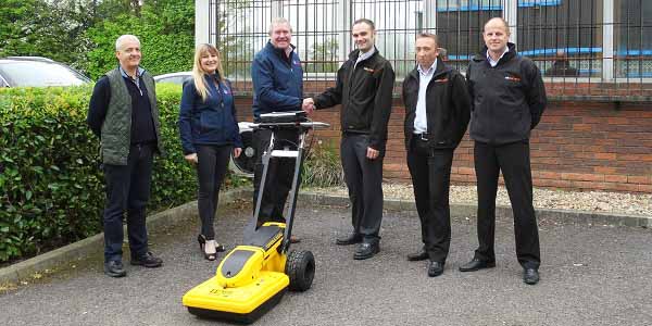
May 2014: World First for MK Surveys Again!
MK Surveys were pleased to take delivery of our latest Ground Penetrating Radar (GPR) System on 30th April 2014. This latest system also happens to be the very first IDS Opera DUO System to be supplied worldwide a position familiar to MK Surveys as we were also the first worldwide recipient of the IDS Detector DUO. The Opera is our sixth GPR system and joins our fleet of IDS Detector DUO’s all of which have been supplied by Drilline Products (UK Supplier for IDS). With continued support (technical, training & presentational) from Drilline, MK Surveys has been able to grow its Utility department from 1 surveyor back in 2007 to the present eight surveyors and two trainees. Pictured left to right are: Paolo Papeschi (IDS Georadar Division), Jill Ticke (Drilline), Colin Ticke (MD Drilline), Gordon Livie (Utility Survey Manager, MK Surveys), Dan Grigg (Operations Manager, MK Surveys) and Stuart Dimond (Director, MK Surveys).
Mar 2014: Radley College
MK Surveys have been appointed by Radley College to provide topographical and underground utility surveys of their site in Oxfordshire. Radley is a boy’s independent boarding school, founded in 1847 and covers 800 acres including playing fields, a golf course, lake and farmland. It is one of four boys-only, boarding-only, independent senior schools in the UK, the others being Winchester, Harrow and Eton. MK Surveys Oxford Office was initially recommended to the Estates Bursar at Radley as a suitable consultant to deliver these services and following a series of meetings and provision of a phased proposal, we are very pleased to have been appointed to deliver these services during 2014 and look forward to maintaining the survey data on behalf of Radley for many years to come.
Mar 2014: Watercourse Survey – Mid Wales
MK Surveys have recently completed a topographical survey along one of the upstream tributaries feeding into Lake Vyrnwy, near to Oswestry in Mid Wales. Purpose of the survey is to assist the client in evaluating potential of the area for small scale hydro generation, with the survey covering an area of circa 1000m by 400m including the spectacular Rhiwargor Waterfalls. With an elevation change of 130m the survey was both technically and physically challenging, the work was carried out by two survey teams and completed within the proposed timescales to the client’s satisfaction.
Mar 2014: City of London
The City of London (City) is the local authority for the “Square Mile” however its activities extend well beyond its administrative boundary as it is also responsible for managing over 4000 hectares of open spaces for the benefit of London as a whole. As part of this responsibility MK Surveys were recently appointed to complete a survey of all engineering assets within Epping Forest, Ashtead Common, Burnham Beeches and Stoke Common. Purpose of the survey was to deliver an accurate GIS database of these assets which include footbridges, access bridges, culverts, dams and spillways for future asset management (primarily inspection, maintenance and asset valuation). MK Surveys utilised the latest hand held Leica Zeno CS25 with external antenna to record all asset information on site.


 mail@mksurveys.co.uk